The Union of the Municipalities of the Basso Biferno is involved, as a partner, in the Crossborder MedPaths project financed by IPA Adriatic 2007-2013, for the valorisation and the promotion of its territory for tourism, together with its partners from the Abruzzo region and Croatia.
The creation of thematic itineraries, bicycle paths for the discovery of natural, cultural, architectural and food and wines resources of the ten municipalities belonging to the Union and of the two municipalities of Croatian origin, Acquaviva Collecroce and Montemitro, represents a strategic choice to favour the sustainable management of the territory for tourism purposes.
The itineraries have been created on already existing provincial roads with limited traffic and can be followed in both directions. This guide and the attached map have been created, together with the project web site (www.eu-medpaths.com), as a support for the visitor to discover and experience the territory of the Basso Molise.
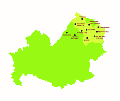
The itineraries created span from the hills to the coastline of the Molise region, located in south central Italy and include the municipalities of Acquaviva Collecroce, Guglionesi, Larino, Montecilfone, Montemitro, Portocannone, San Giacomo degli Schiavoni, San Martino in Pensilis and Ururi in the Basso Molise area and the coastal municipalities on the Adriatic Sea of Campomarino, Montenero Di Bisaccia and Petacciato.
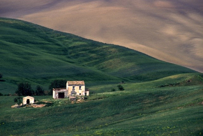
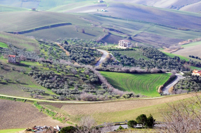
The territory of the Basso Molise area is typically hilly, the visitor can enjoy landscapes characterised by vineyards, olive groves, Mediterranean maquis, dunes, humid environments, woods and farmland. Following the inner roadways, the visitor can discover suggestive places from a naturalistic point of view and visit farms, wineries, oil mills which represent a safeguard of local food and wine, characterised by excellent extra virgin olive oil, high quality wines, cheese, typical cold meats and traditional dishes.
Following these inner roadways, the tourist can visit the single municipalities featuring rural characteristics such as suggestive hamlets, castles, cathedrals, archaeological areas surrounded by farmland and natural landscapes and animated by the rites and traditions which take place every year coinciding with religious events.
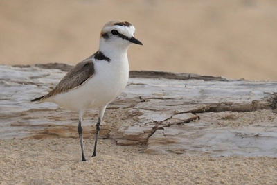
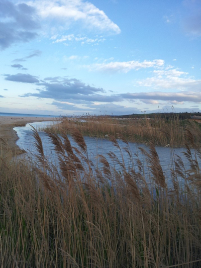
The coastline has large, sandy beaches with humid environments of an important naturalistic value, rich in flora and fauna of a rare beauty.
THE ITINERARIES
The principle roadways of the Basso Molise area are characterised by the Fondovalle of the Biferno and by State Road 87, from these branch the inner roadways which lead to the various municipalities, characterised by tracts that follow the natural morphology of the territory allowing for a slower course, in function of the tourist wanting to visit the Basso Molise area on bicycle and fully enjoying the wonderful landscape and the hamlets offered by the area.
From this dense and meandering network of roadways and secondary roads servicing the twelve municipalities, three itineraries have been created with three specific themes: Nature, Food and Wine and History. Each itinerary, regardless of its theme, touches upon all of the aspects of the territory, of nature and of the history and of the culture. It can be enjoyed by both the more athletic cyclists as well as by those who simply cycle for pleasure, with bicycle paths in every single community averaging a distance of 10-15 kilometres.
Info-points in the municipalities of Petacciato, Campomarino, Larino, Guglionesi, Montenro di Bisaccia and Acquaviva Colllecroce, specific signs placed along the individual paths, info boards and areas for bicycle parking in all of the municipalities along the itineraries, a web site (www.eu-medpaths.com) filled with information regarding the nature, history and culture of the territory of the Basso Molise area, including detailed maps of the itineraries, will allow the tourist to enjoy the itineraries, visit archaeological areas, the nature areas, the churches, the hamlets, the wineries while savouring the traditional dishes and typical products with ease.
Landscape Basso Molise
Landscape Basso Molise
Lake of Liscione
BLUE ITINERARY - NATURE
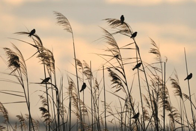
The protagonist of this itinerary is the hilly landscape which can be seen in proximity to the Adriatic Sea. The SIC area "the mouth of the Trigno-Marina of Petacciato" is of particular naturalistic interest, as it is part of "Rete Natura 2000" which includes the entire marina areas of Montenero di Bisaccia and of Petacciato. They are characterised by sandy beaches, coastal dunes, retro-dunal environments and pine forests. Another two internal municipalities complete the itinerary, Guglionesi, a hamlet of historical, architectural and archaeological importance and San Giacomo degli Schiavoni,
Stops : Petacciato, Montenero di Bisaccia, Guglionesi, San Giacomo degli Schiavoni
Flora and Fauna
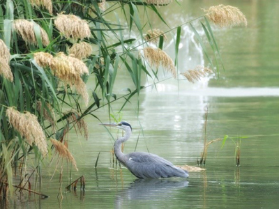
Flora and Fauna
PETACCIATO
Petacciato is a coastal town of antique origins, in the years, it's territory was contested by numerous populations: the Goths, the Byzantines and the Lombards.
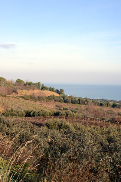
The peculiar aspect of Petacciato is represented by the hilly landscape which reaches the coastline, with an abundance of vineyards and olive groves. The humid coastal environment and the pine forests enrich our visit with suggestive landscapes (dunes and retro-dunal environments) full of flora and fauna which are being protected and preserved thanks to various initiatives.
For the quality of the water, of the services and of the protection of the eco-systems, Petacciato received the "Blue Flag" for the first time in 2012 as one of the best beach areas in Europe.
In the historic centre, there is the Church of San Rocco, dedicated to the patron saint of the town, in Romanesque style and dating back to the XI-XIII centuries and the Ducal Palace of medieval origin, which following several restorations, lost its military structure and today presents itself as an exclusive residence.
In the "Marina of Petacciato", along State Road 16 which flanks the Adriatic Sea, there is the Tower of Petacciato, an antique coastal lookout point at 7 metres above sea level.
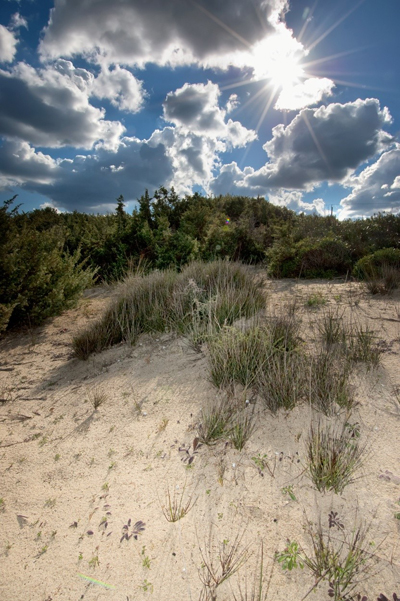
Dunes Petacciata
landscape Petacciata
MONTENERO DI BISACCIA
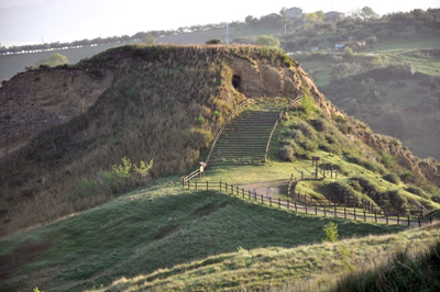
Findings dating back to the Paleolith are witness to the possible antique origins of this coastal town, which rises from an argillaceous hill facing the sea. In the caverns of tuff, probably primitive dwellings, fossils belonging to the Paleolith and pieces of terracotta vases dating to the Neolithic age were found.
During the Christmas period, the caverns of tuff become the ideal setting for the re-enactment of the birth of Christ in the costumed interpretation of the Nativity Scene.
The hilly landscape is characterised by vineyards and olive groves reaching the sea, where a large, sandy beach becomes the ideal spot for a tranquil summer holiday.
Worth a visit are the Tower of Montebello, a coastal lookout point dating back to the XIII century, 12 kms from town; the Shrine of Maria Santisssima di Bisaccia on top of a hill, at 900 metres from the town centre and the churches of San Matteo Apostolo and San Paolo Apostolo.
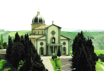
Shrine of Maria Santisssima di Bisaccia
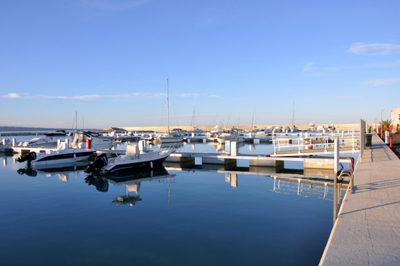
Marina of Montenero di Bisaccia
Cave of the Madonna di Bisaccia. Montenero di Bisaccia
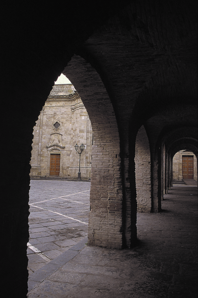
GUGLIONESI
The origin of this town's name, according to some researchers, could possibly derive from "guglia" a typical aquatic plant found along the banks of the Biferno river.
It is situated on a hill where one can admire the geometric shapes and colours of the farmland, the olive groves, the Valley of the Biferno and the Adriatic Sea.
The three principal and parallel roadways delimit the beautiful hamlet of medieval origins where it is possible to visit some of the most beautiful monuments of the Molise region.
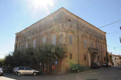
The Church of Santa Maria Maggiore, in Baroque style - of the antique Romanesque church only the crypt of San Adamo remains - is characterised by a tripartite façade and within its walls, it contains an important historical and artistic patrimony (the sliver statue of S. Adamo of 1729 and two paintings from the late 1700s, S.Adamo by Pietro Bardellino 1786 and The Last Supper by the Neapolitan painter, Ferdinando Castiglia 1800).
The Church of San Nicola has very antique origins, even if the monument visible today was built at the beginning of the XIII century, and represents a wonderful example of Medieval and Romanesque style.
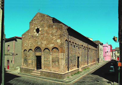
Church of San Nicola. Guglionesi
Arcades. Guglionesi
Landscape Guglionesi
SAN GIACOMO DEGLI SCHIAVONI
It's origins date back to the XVI century, even if in the San Pietro area, the remains of a Roman Villa built in the Republican era have been found.
It's name recalls the origins of the town, when the "schiavoni" (a population of Slavic ethos) settled the small village and transformed it thanks to their farming abilities into a community. Worth visiting are the excavations of a rustic villa and the Church of Maria SS del Rosario.
RED ITINERARY - FOOD AND WINE
Culinary art, wine and oil production represent a stronghold of the entire territory of the Basso Molise area, where simple recipes, excellent primary materials and artisan methods of manufacturing and production resume balanced flavours and scents, which recount a unique and welcoming territory.
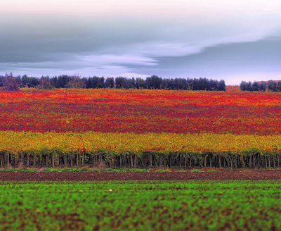
It is in the countryside of Campomarino and Portocannone, where the slightly sandy and rolling fields and the sea breeze compete to create a particularly favourable environment for the cultivation of vines and in particular the vintages of Trebbiano and Montepulciano for the two DOC wines, "Biferno" and "Molise".
The numerous wineries, principally privately owned, present along this circular itinerary are an "open space" for tours and wine tastings to gain a profound knowledge of the fascinating world of wine and of the territory that produces it.
Stops: Campomarino - Portocannone
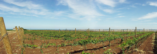
Cultivation of vines
CAMPOMARINO
Campomarino becomes an important centre during the Lombard and Norman period, after the 1456 earthquake, it becomes repopulated thanks to Albanian refugees who were escaping the invasion of the Turks. In fact, today it still preserves the Albanian dialect.
It is a place for excellent wine and wonderful expanses of vineyards which reach the sea.
Besides the beach area full of sea-loving tourists, the coastal area of Campomarino belongs to two sites of "Rete Natura 2000" characterised by very rare dunal and retro-dunal habitats which are worth a visit. For the quality of the water, of the services and the protection of the eco-systems, Campomarino first received the "Blue Flag" as one of the best beach areas in Europe in 2007.
The ancient hamlet rises facing the sea and is surrounded by cultivated fields.
Worth visiting are the Church of Santa Maria a Mare and the Murals.
Archaeological findings (The Village of Campomarino) are witness to the antique origins of this municipality.
Cultivation of vines Campomarino
PORTOCANNONE
The origins of Portocannone date back to the year one thousand, in 1456 when an earthquake destroyed it completely, it remained uninhabited until the arrival of the Albanians.
It is characterised by a medieval hamlet where one can visit the Church of Carmine and the Church of SS Pietro e Paolo along with the Cini-Tanasso Palace, the residence of the Cini family which became the patrons of Portocannone in 1735.
Farmland, olive groves and vineyards characterise the countryside landscape of Portocannone, and secular olive trees, some around 600-700 years old, have now become a natural patrimony of the territory.
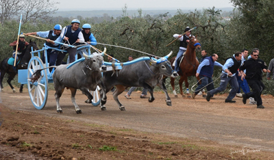
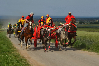
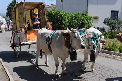
On the Monday following Pentecostal Sunday, an ox-cart race takes place, a tradition of distant origins which re-enacts the finding of a new home by untamed oxen let loose and guided by the image of the Madonna di Constantinopoli.
Cini-Tanasso Palace. Portocannone
ORANGE ITINERARY - HISTORY
The theme of this itinerary is the history of the territory and in particular, the arrival of families from the other shore of the Adriatic Sea, who repopulated the territories of the Basso Molise area almost completely uninhabited, also because of the disastrous earthquake in 1456.
Croatian families settled the territories of Acquaviva Collecroce, Montemitro and San Felice del Molise, and Albanian families settled in the territories of Campomarino, Portocannone, Ururi and Montecilfone.
A regional law (no. 15 - May 14 1997) recognised the Croatian and Albanian linguistic minorities as immaterial culture patrimony of the Molise region. A cultural patrimony which is possible to experience, understand and photograph following the proposed itinerary and stopping over in the municipalities of the "Carresi" (ox-cart races), of the two languages, of the religious events and of the culinary traditions bound to the land of origin. Suggestive naturalistic outcroppings encapsulate the history of these territories.
Stops: Campomarino , Portocannone, San Martino in Pensilis, Ururi, Larino, Montecilfone, Acquaviva Collecroce,Montemitro.
Carrese
CAMPOMARINO
Campomarino becomes an important centre during the Lombard and Norman period, after the 1456 earthquake, it becomes repopulated thanks to Albanian refugees who were escaping the invasion of the Turks. In fact, today it still preserves the Albanian dialect.
It is a place for excellent wine and wonderful expanses of vineyards which reach the sea.
Besides the beach area full of sea-loving tourists, the coastal area of Campomarino belongs to two sites of "Rete Natura 2000" characterised by very rare dunal and retro-dunal habitats which are worth a visit. For the quality of the water, of the strives and the protection of the eco-systems, Campomarino first received the "Blue Flag" as one of the best beach areas in Europe in 2007.
The ancient hamlet rises facing the sea and is surrounded by cultivated fields.
Worth visiting are the Church of Santa Maria a Mare and the Murals.
Archaeological findings (The Village of Campomarino) are witness to the antique origins of this municipality.
Avifauna Campomarino
Campomarino
PORTOCANNONE
The origins of Portocannone date back to the year one thousand, in 1456 when an earthquake destroyed it completely, it remained uninhabited until the arrival of the Albanians.
It is characterised by a medieval hamlet where one can visit the Church of Carmine and the Church of SS Pietro e Paolo along with the Cini-Tanasso Palace, the residence of the Cini family which became the patrons of Portocannone in 1735.
Farmland, olive groves and vineyards characterise the countryside landscape of Portocannone, and secular olive trees some around 600-700 years old, have now become a natural patrimony of the territory.
On the Monday following Pentecostal Sunday, an ox-cart race takes place, a tradition of distant origins which re-enacts the finding of a new home by untamed oxen let loose and guided by the image of the Madonna di Constantinopoli.
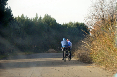
Cyclists
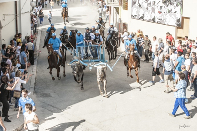
SAN MARTINO IN PENSILIS
Positioned atop of a hill, thus the name "in pensilis", the town started to develop around a place of worship dedicated to "San Marino". Every year on April 30, the "Carrese" in honour of Saint Leo takes place. It is a race with carts pulled by oxen having its start line at the cattle track and its finish line within the walls of the historic centre of town, covering a distance of 9 kms. This event attracts many tourists and enthusiasts and it is experienced with exceptional intensity by the town's inhabitants and by the participants.
Together with the "Carrese", there is a pork-based preparation called Pampanella to complete the identity of San Martino in Pensilis.
Worth visiting are the Baronial Palace, the Church of San Pietro and the Convent of the Capuchins of Gesù Maria.
Landscape San Martino in Pensilis

Carrese San Martino in Pensilis
URURI
A town of Albanian origin, in 1561 the feud was entrusted to the power of Teodoro Crescia, an Albanian and from that moment forth the community developed in harmony and tranquility.
The rites, customs, language and tradition of the land of origin are still preserved. On May 3 the "Carese" takes place. It is a race with carts pulled by oxen starting at the Pantoni farm and finishing, after 4 kms, in the historic centre of the town in front of the Church of Santa Maria delle Grazie, all in honour of the SS Legno della Croce, which is carried into procession by the winning cart on May 4.
Worth visiting are the Church of Santa Maria delle Grazie and the Baronial Palace, the present seat of Municipal Hall; a taste of the local culinary traditions is a must.
Landscape Ururi
Carrese Ururi
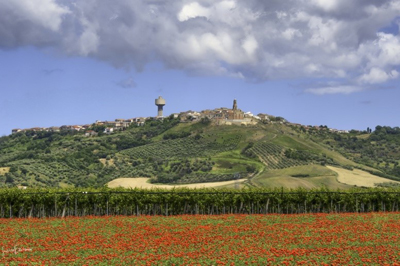
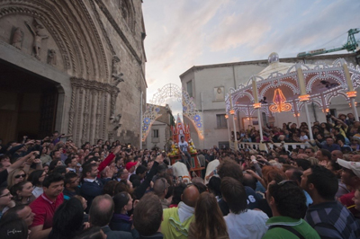
LARINO
Larino is without doubt one of the most interesting places in the Molise region from a historical point of view. It was founded in the pre-roman period (the Frentani people), during the Roman period it became an important city with the presence of the forum, the thermal baths and the amphitheatre. It played an important role from a cultural and economic point of view. Visiting it and experiencing its traditions makes these past aspects re-emerge.
The most important of the ancient remains is the Roman Amphitheatre, together with the polychromatic mosaics now conserved in the Civic Museum. The most interesting among the churches is the Cathedral of San Pardo, consecrated in 1319, it represents one of the most significant examples of religious architecture from the XIII and XIV centuries of central Italy. Near the cathedral, there is the Ducal Palace of medieval origins and the seat of Municipal Hall. In the month of May, from 25 to 27, the "Carrese of San Pardo" takes place. it is bound to the propitiatory rites of the awakening of nature as are the other "Carresi" in the area.
This "Carrese" is not a race but a procession of over one hundred carts pulled by oxen that parade from the historic centre towards the upper part of town and vice versa during the three day festivities.
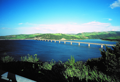
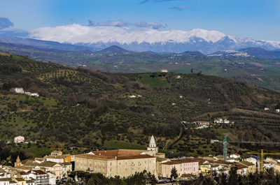
The landscape is also characterised by gently sloping hills full of olive groves which allow for the production of the renown oil extracted from an autochthonous cultivation the "Gentile of Larino" and from the Larino bank of the Lake of Liscione, an artificial lake formed by the barrage of the waters of the Biferno river.
Carrese. Cathedral of San Pardo. Larino
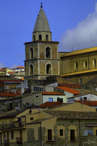
Bell tower of San Pardo
Landscape Larino
MONTECILFONE
In the XV century, the Albanians also settled in Montecilfone, repopulating an almost uninhabited area because of the 1456 earthquake and favouring the productivity of the land. Not far from the town centre, one can enjoy the beauty of the Corundoli Woods, a hill of about 80 hectares covered in hardwood trees (turkey oak, holm oak and durmast) which can be admired along with a colourful flora and fauna, following the trails throughout in the woods.
In the month of June, there is a parade of carts pulled by oxen in honour of Saint Anthony. The town is atop of a hill from which one can admire the olive groves and the farmland and an important tract of the Biferno river.
Worth visiting in the historic centre of the town is the Church of San Giorgio Martire, re-built on a pre-existing structure.
Parade of carts pulled by oxen in honour of Saint Anthony. Montecilfone
ACQUAVIVA. COLLECROCE
A town of Slavic origin, of which it preserves both the traditions and the language. It can be considered a bilingual town where Italian and a dialect deriving from the Croatian language are both spoken. The stokavo-ikavo language dates back to the 1300-1400s. All the signs, both municipal and commercial, are written in both languages.
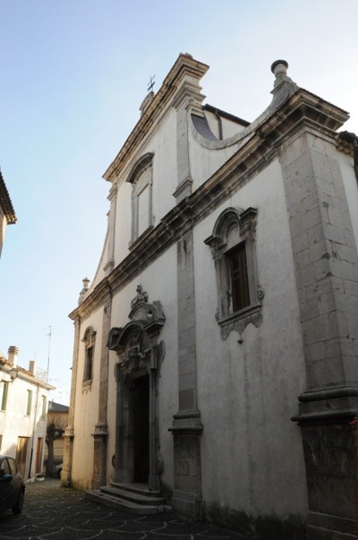
It is located between the Biferno and Trigno rivers at about 30 kms from the Adriatic Sea. In the hamlet, characterised by small allies and lanes, it is possible to visit the Baroque Church of Santa Maria Ester, with the Cross of Malta on its portal, indicating that the area was part of the holdings of the Order of Malta up to the first half of the 1400s.
Another feast bound to the auspicious rites of a good harvest is the "Festa del Maja", it takes place every year in Acquaviva Collecroce on May 1. "U maje", a man wearing a cone covered in branches, flowers and various vegetables, parades around town in the company of musicians and singers.
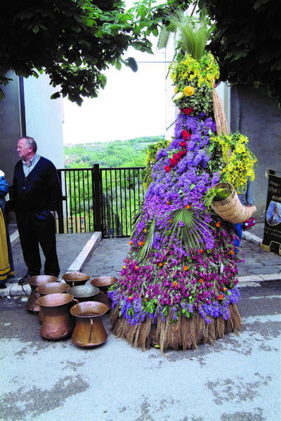
Festa del Maja. Acquaviva Collecroce
Church of Santa Maria Ester. Acquaviva Collecroce
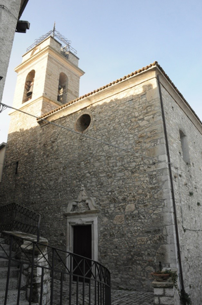
MONTEMITRO
Like Acquaviva Collecroce, it is a town of Slavic origin, of which it preserves the traditions and the language. From the tower situated in the historic centre, it is possible to admire the waterway of the Trigno river.
Worth visiting is the only church present in town, the Church of Santa Lucia, in Gothic and Baroque style, probably the outcome of a transformation of a more antique construction.
Three kilometres from the town centre, there is "Lago Grande", a beautiful green oasis of small dimensions but well equipped for a relaxing stop at the end of the itinerary.
Church of Santa Lucia. Montemitro