The Union of Municipalities of Sinello, established in 2003, represents 7 Municipalities located in the Region of Abruzzo. They belong to a territory with rich cultural heritage since early history. Nowadays the Union acts as a cultural catalyst connecting the coast of Adriatic Sea with the internal zone of Sinello Area. It represents an area with dense cultural potential, visible in the original structures of the past. In fact, population and decision makers have luckily managed to conserve the historical and cultural heritage, handicrafts and the arts, assets which have greatly developed alternative forms of tourism in the area. The Union systematically pursues coherent policies of sustainable development and government of the cultural values in his own territory, creating, in the last years, networks among the Municipalities and other regional neighbours. It has experience in collecting and good practices in culture, tourism, transport, models to prevent environmental hazards, environmental protection and community governance.
The Union of Municipalities of Sinello includes seven municipalities: Guilmi, Carpineto Sinello Montazzoli, Torrebruna, Carunchio, Palmoli and Celenza sul Trigno. The territory of the Union is typically hilly: the visitors find themselves in front of beautiful landscapes characterized by woods, lakes, rivers, farmland and from its hills you can see both the Adriatic Sea and the mountains of Maiella. The Union is characterized by a strong attachment to traditions farming, breeding and cultivation of land that produces excellent products typical of this area (meats, cheeses, honey, sweets, homemade pasta, wine and extra virgin olive oil). Among other things, it is an area rich in cultural heritage: every village has its castles, museums, churches and places of worship around which religious, cultural and folkloristic events take place.
Situated 674 meters above sea level, Guilmi has a great location being located midway between the sea and the mountains, and it has a landscape of exceptional beauty.
The altitude, the exposure, the health, the richness and variety of vegetation, the rarity of some wildlife species, the significant distance from major industrial centers, and low density, make this village a true green paradise of relaxation, health and food.
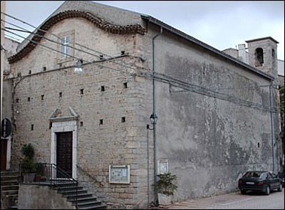
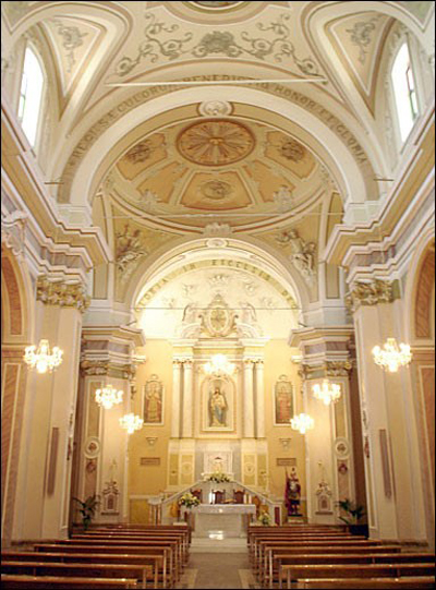
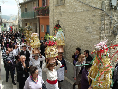
Among the places of most interest there is the church of "Santa Maria Immacolata" which is the most important building in the village because of its history. Inside many religious events are celebrated . The most important is the feast of San Nicola (on May 5th), which is the saint patron of the village. On this day the original religious procession is characterized by the presence of the statue of the saint, brought to arms by the devotees and the parade of “ch’nocchie” (pyramidal structure with three or four shelves stuck inside a bowl filled with grain and typical products) covered with sweets including pizzelle and castelli and adorned with sugar, chocolates and sugared almonds. These are carried in procession by the women (on the head), and children dressed in traditional costumes. The parade is followed by the traditional "riff" (auction) where they sold the “ch’nocchie” and other typical local products, offered by the inhabitants. The proceeds from this will be donated to the Church and will be used to finance all the works that the Church considers it useful to do.
The initiative to collect and preserve objects of peasant life was created through the work of volunteers who, with patience and dedication, they have created the museum. The objects in the exhibition are placed in the various categories of trades, are named in the Guilmi dialect and for each is indicated the use. There are tools for the care of livestock and barn, for the processing of wool and hemp, household items, furniture furnishings, etc..
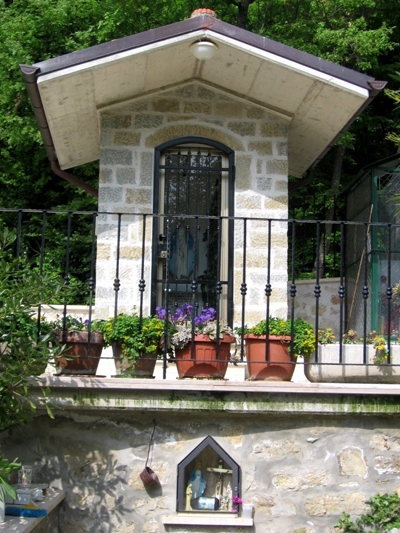
Guilmi is surrounded by forests and natural places of great interest with its variety of vegetation. In its surroundings there are several sources such as the “Fonte del Fico” (recently renovated) and the “Fonte Paradiso”, a place of extraordinary natural beauty with its old oak tree and a place of worship, as it is reminiscent of the miracle that took place in 1991 to a lady of Guilmi, recovered in the hospital, seriously ill. With the apparition of the Virgin Mary, the woman's husband discovered this spring, whose water miraculously cured the woman.
The nature that surrounds the village is of such beauty that has been a source of inspiration for many artists, that during the summer staying at Guilmi. Noteworthy is the “Omone” of Dem, completely immersed in nature and built with the vegetation of the place.
Guilmi is also famous for its Ventricina , the main product of the guilmese culinary. It is a rarity food, with unique aroma and flavor internationally known. The uniqueness of this product is guaranteed by the "savoir faire", the genuineness of the spices and the type of traditional farming of pigs that eat wheat and acorns. The climate and healthy air contribute to the exquisiteness of this salami that so many have tried in vain to imitate. Its production is strictly artisan level, the quantity is so limited. The processing period is from mid-December to mid-January because the cold promotes conservation. It is produced using the noble parts of the pig. The day of the festival of Ventricina is the 14th August.
CARPINETO SINELLO.
Carpineto Sinello owes its name to the nearby Sinello river and the woods of blacks hornbeams. The village is located on a hill at the foot of Monte Sorbo. The center overlooking the valley of the river Sinello. Among the various centers that dominate the valley of Sinello river, Carpineto Sinello has the greater physical dependence by the proximity of the river: the territory was very equipped with the mills (the land offered plenty of wheat, as well as olive oil and wine to be sold outside of the village) and the fishing was very active.
The Ducal Castle has a great importance. The original structure dates back to the fourteenth century with successive transformations. The castle was the residence of the feudal lords; gradually it became a fortified palace. The building was erected around an existing medieval tower with a square base. It is located in Via Salita Castello in the top of a hill. The structure is composed of several bodies: the tower, the residential building and a courtyard. The used materials are calcareous stone and sandstone. In residential building there are wall paintings and decorations.
The Pig Museum is located near the Ducal Castle in Via Salita Castello and it is divided into five sections covering an area of about 1000 square meters:
- Who is the pig;
- The story of the pig in the Italian culture and rural economy from Roman times to the present day;
- The educational area;
- The breeding and marketing of pigs in the economy of central-southern food: the historical role of Carpineto Sinello
- The art of charcuterie in Abruzzo between past and present.
In different rooms you can watch ethnographic exhibition movies on the pig slaughter and meat processing, costumes, photos and comic books, furniture and tools for slaughtering and meat processing (spoons, bowls, forks, ropes, etc..) and much more. In the property there is also a tasting area and purchase, where you can taste and buy the products that the visitor has previously observed and admired in the exhibition rooms.
MONTAZZOLI.
Montazzoli is located on a mountain between the Sinello River and the Allosa Torrent. It is situated 850 metres above sea level. The country retains the original structure, as the particular topography of the area is composed of two hills opposite, separated by a small plain on which have been built homes more recent. Montazzoli has many important churches (the Church of Santa Maria della Spogna, the Church of Sant’Antonio, the Church of San Silvestro Papa), monuments and buildings of great importance, such as the Recchia Palace and the Castle. Some scholars believe that the castle to have originated from a square tower located in the courtyard at the north side who controlled the northern part. An outdoor courtyard to the east consisted of mill, crushers and warehouses. Access to the castle is possible through two streets that end in the outer court. The oldest street is located at the old factories and warehouses, road today no longer feasible, the other way, the case of carriage path and reached from the south via a drawbridge that serves a cobbled stairway opening onto a plane with a view. The north facade was rebuilt after the earthquake of 1907, the facade of which remains a buttressed base and a small corner portion. Through a portal in sandstone and limestone you enter a courtyard covered by a barrel vault with lunettes where there is preserved the beam put in function the drawbridge. From the courtyard you can get in some apartments, formerly used as stables and servants' quarters and made habitable by the last heirs of his vassals is Franceschelli in 1920, the cellars and the former prisons on which there is a block of sandstone with written "Nolite Nocere" which means "Do not hurt." From the courtyard there is a ramp that puts in the fourth noble divided into several private apartments and only one of them inhabited by the descendants of the feudal lords. The current shape is due to the XVI-XVII century.
TORREBRUNA.
Torrebruna is an ancient mountain village situated on the slopes of the Apennines, close to the mountain known as the "Torrebruna" and south-east of the Carunchina and Civitella hills. Its position overlooking the valley of the river Trigno beyond which lies the province of Campobasso in Molise Region. As a village of medieval origin has a fortified borough characterized by its structure and buildings typical of the medieval period. Also there is the most famous Parish Church of the Transfiguration, an example of Baroque art. Torrebruna is placed in a location particularly happy as it can connect, in a short time, with coastal areas and those with the highest mountains.
The public fountain of Torrebruna was built in 1797, date transcribed on the band at the junction of tubes. Placed in an elevated position respect to the city centre of the country and its access, intercept groundwater that originate at the above valley, used by passers-by crossing the road called “tratturo” from Atelea-Biferno towards Castiglione Messer Marino Village. Aside from the date of the first construction work performed on it can be dated with certainty to September of 1817 when the master of the country Domenico Marianacci carried out a survey to the water that is the source itself.
The fountain, over the years it underwent further restoration work, so it is likely that a first arrangement started in the late XVIII century. is then completed and finished with the work carried out in the decades between 1812 and 1817. This is demonstrated by the fact that you do not speak more than restoration until 1836-1838. In 1853 Vincenzo D'Ettorre who was in Torrebruna for jobs to urban roads, it also makes maintenance of the fountains. The latest round of work was that of 1909. The fountain is of classical form, consisting of two large arches, made of blocks in regular light stone, bordered by just projecting pilasters, surmounted by a large cornice. Inside there are a wash on the right side and a trough in the left. On top of that spouts out from the frames circular stone fountain is accessed through more stone steps. Above the left pilaster is an inscription.
The Fountain is well preserved thanks to the many restoration works carried out over the years.
CARUNCHIO.
Located high in the hills and mountains of the interior of Abruzzo Region Territory, Carunchio is a small village; from the XII and XIII centuries it has always been occupied by a thick dense network of guard posts, sightings, isolated towers, fortified farms to the largest castles and all tied together by a system of triangular connections made on alert the entire territory in a short time, regarded as the most significant route of penetration all inside had been, and still remain with valleys, the alluvial river. The urban area very disjointed still largely the typological original in the alleys and terraces that slope down to the Nocicchio street through the old part with the modest expansions later. In the historical centre: Turdò and Castelli Palaces, parish churches of St. Giovanni Battista. Outside the perimeter, the church of Purgatorio.
Carunchio is know for “Infiorata”. Art, faith, tradition and folklore are the soul of this event that offers moments of communion and community throughout the country, who was a guest who feels a living part of this event. One of those traditions that are carried on for centuries and keep busy the whole country, also attracting many people from all over the Abruzzo Region and also from other neighbouring Regions. Sunday in Corpus Domini also the streets of the historic centre of Carunchio will coat a beautiful floral carpet.
All the Community participates directly in the work of the makeshift floral painters, expressing their joy of the season, opening doors and windows along the entire route of the procession, enriching it with blankets and tablecloths on display as a sign of a deep devotion to the Eucharist. Today, the event has grown, it is known beyond the borders of the territory of Carunchio.
It 's always been the tradition decorate with flowers, altars, sheets and blankets the route of the procession of Corpus Christi, thing, this, that with the passage of time, from simple popular custom became even sublime art form. From flowers thrown together on the pavement you move gradually to the exclusive use of petals and leaves evergreen, with which to make rugs and paintings reproducing scenes from the New and Old Testament. Enthusiasts prepare the flowers of Carunchio work for several days prior to the occurrence in order to ensure a successful outcome to the event.
The purpose of the event is essentially to keep alive through the pictures of flowers, the deep religious faith towards the Eucharist and cultural prestige, but also want to spread new meanings and artistic content of friendship between peoples. The floral display real takes a few hours, from morning until late afternoon and it's time truly collective event where a large number of people work with a lot of enthusiasm and a lot of patience.
PALMOLI.
Palmoli is located in a hilly internal area. The old town is full of buildings, evidence of the past. It has several monuments, important to understand the origins of this people. It is an important centre for woodworking. The prestigious castle is located in the centre of the lovely village of Palmoli, located in a solitary hill, in the area of Vasto and a few kilometres from the Adriatic coast. The Marquis Castle is the most impressive landmark and significant throughout the country and in 1928 was declared a national monument. The entire complex consists of fortified defensive walls and a tower dodecagonal and incorporates the Palace marquis (the fifteenth century) with the chapel of San Carlo (XVIII cent.). The castle is also home of the Museum of Rural Life since 1978. Inside the village, full of courtyards, porticos, stone portals, fanlights and wrought iron railings, there is the Church of Santa Maria delle Grazie, Tuscan-style composite, probably attached to an older church in 1300. Particularly rich in plaster, paintings, statues and decorations, the church houses a bronze casket with the body of the patron saint of Palmoli, San Valentino Martire.
The castle, according to tradition, was built in 1095 by Pandulfo di Sangrof rom the Counts of Monteodorisio, the same popular tradition remembers that were built at the same time by three brothers of the family Di Sangro three castles: to Monteodorisio, the Castle of Furci and the Castle of Palmoli in the end of the county. The three castles were aligned and communicated with each other during the day with poles and pillars of smoke at night with fires. In the Bourbon period (1772) the Marquis of Severino Gagliati built the Chapel of San Carlo annexed to the castle. The marquis palace currently houses the municipal offices.
The marquis palace has got a “L” plan and comprises a number of styles related to a period of time ranging from the XV to the XIX century. The mighty tower, a dodecagonal plan, is home to the Museum of Rural Life, in which there are objects ranging from tools to clothing characteristic of work.
The main material for construction is local limestone and sometimes well squared (in the canton corner or in the arches of support. To the eaves is used brick, brick and tile placed on file and protruding on the front). The galleries of the balconies are made of limestone more compact called “Istrian stone”. Scattered here and there you can admire the architectural elements in sandstone, in gray-green colours as the marquis palace. Investigations have brought to light the city walls and a water pipe in brick adjacent to the shoe on the south side of the polygonal tower.
CELENZA SUL TRIGNO.
Celenza sul Trigno is located on a hilly ridge between the streams Vecchio and Caccavone, to the left of the middle valley of the Trigno river. The town enjoys a beautiful view thanks to the spectacular views of the Maiella, the Matese, the hills and the Adriatic sea.
The meaning of the Celenza name, though in connection with the Latin caelum, remains a mystery.
The discovery of archaeological finds from the Roman period could testify that the territory since ancient times, has hosted a settlement. Celenza retains traces of its past in the seventeenth-century tomb of the princes Pignatelli-d'Avalos that is located in the parish church of Santa Maria Assunta, and also in the superb watchtower along the Trigno river, the Tower “La Fara”, so named because it is located in the homonymous district.
Church st. Antonio
Church “San Silvestro Papa”
CChurch “Santa Maria della Spogna”
Fonte Paradiso
Procession st. Nicola